Kilometer 2:
The second kilometer was quite like the first, except the trail included more and more stairs as their was an elevation change of 698 feet. I had to shed a few layers as more work had to be done but the weather was still holding up and I was feeling great. Knowing that the weather can change in a matter of minutes I had to keep my fingers crossed but mentally I was sticking to what I could control: my pace.
Summit looking clear
Kinabalu Valley
Kilometer 3:
At this point I was still feeling great only having taken a few rest stops, mostly to stay hydrated but not wanting to stop too long as I was moving quickly. This was also the first time I really saw a change in the path as the dirt turned to rock and I had to carefully navigate through them. The sun was still shining, but unfortunately this was the last time I'd see the sun today.
No longer an easy trail
Kilometer 4:
This is when the journey got interesting as in a matter of minutes the weather significantly changed and I was now in thick clouds. I also began to pass the people who were coming down from the previous days 2-day hike. At one rest stop I chatted to these two girls who said the sunrise at the summit was spectacular and no matter how difficult the climb it will be unbelievably worth it. Unbeknown to them this later proved to be a driving factor for me to get to the top. Feeling strong I set a quick pace (with Felix right behind me) while continuously passing people coming down. I was amazed at some of the mountain guides and porters coming down the trail. A few were carrying multiple backpacks, some kerosene tanks and others smoking cigarettes. Only if they knew how frustrating it was to see them making this trek look like a piece of cake (the mountain guides do the summit trail twice a week so this was nothing for them). Change in elevation of 951 feet since previous kilometer.
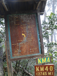

Felix on the way up
Why not carry two backpacks?
Clouds begin to roll in
Kilometer 5:
The last kilometer before reaching the first check point: Laban Rata Guesthouse. With the visibility diminishing and the trail becoming more and more difficult, for the first time I began to feel the altitude as my steps became smaller and smaller. I was still feeling good and knowing I was almost to Laban Rata I stayed strong. Instead of keeping the goal in mind of reaching the summit, I shifted strategies by setting shorter distance goals and was now only thinking of getting to Laban Rata and would worry about the summit later. My pace noticeably diminished as the stairs were larger and larger and the terrain more and more difficult. I also noticed that the vegetation changed dramatically from a dense jungle to shorter trees and shrubs as we were now up to 9,845 ft in elevation. Through the thick clouds I finally saw the Laban Rata Guesthouse where we arrived at 10:50am, 3 hours and 5 minutes after the start. I was thinking what a pace and I'd have no problem getting to the summit by 1:00pm and I'd probably be back to the base by 4:00pm Oh how wrong I was.
After about a 20 minute stop, a quick lunch and a change to a dry shirt we were getting ready to head out when the rain began. I looked at Felix who didn't have too promising a look on his face but he suggested we wait it out to see if the rain would let up. While waiting, one of the other guys, Zack, who was doing the day trek caught up to us. Feliz and I, and Zack and his guide hung around for another 20 minutes until fortunately the rain let up and we were able to start up again.
Jungle...
...quickly changes to shrub and short tree vegetation
No biggie
Laban Rata
Felix and I waiting for the rain to stop
Kilometer 6:
After warming up and filling up with food at Laba Rata I was feeling great, highly energized and my legs staying strong. I was amazed how after about 10 minutes all of that disappeared. The rain turned from a mist to a steady downpour and the trail no longer existed as we got above the tree line and most vegetation disappeared and we were faced with solid rock and a rope to pull ourselves up the last 2.75 kilometers. On top of that, small waterfalls began to appear as the rain water was washing down the mountain which caused for a tough obstacle. As difficult as it may seem it wasn't bad going up in these conditions but I was wondering how hard it would be to come down.
Stairs were tall and rocky
Last of the vegetation
The rope begins...notice the water coming down
at the top left corner.
Kilometer 7:
The rain was constantly pouring down and at this point I was waiting for our guides to tell us we had to turn around. With each passing minute and the rain not stopping I was surprised to hear the guides remain silent. With only 1.75 kilometers to go I felt rejuvenated and could focus on reaching the top. It was at this point that Zack's leg began to cramp up and he was having a tough time going forward. With the visibility seriously diminished (reduced to about 10 feet) I thought there'd be know way we'd be able to keep going. I turned to the guide who looked at me and said it's up to us if we want to keep going. He suggested to Zack that for his own safety he turn around because a cramp would seriously hamper his ability to make it down and at this elevation and rock surface no one could carry him down and he'd have to make it on his own no matter what injury he had. I thought Zack would turn around (no matter what he decided I was still going to push on) but to my dismay he stuck with it. Surprisingly I was still feeling really good, a bit tired, but the adrenaline seriously kicked in as I was within 1km of the summit. They say that a lot of people turn around with only 1km to go, but there was no stopping me unless the guide said so. I asked him if he thought it was too dangerous up there and he said "it will be thick clouds and rainy, but it's up to you." We pushed on.

Almost there!
The summit is somewhere at the end of the rope
Visibility was not so good
Zack pushing through the pain and
the clouds
Kilometer 8:
So close, only .75km's to go!! At this point you feel like you hear your heart pounding in your head and your steps take more energy then before but you can't stop but think how close you are. I can only imagine how discouraging it would be to have to turn around. The visibility remained bad but fortunately the clouds separated a bit and the sun was trying to come through. This was very encouraging and the guides said how lucky we were and let us make for the summit. We continued following the rope and were within 100m to the top when the flat rock changed to boulders which was certainly demoralizing and wound up being one of the hardest parts of the entire trek. Tired and with my heart pounding I slowly, step-by-step made it over and around the boulders with the top not looking any closer. Within 50 meters the guide stopped and told me to lead him to the top. That last step to the top felt amazing and with my arms in the air I let out a huge yell that echoed all around us. I made it!!!! Low's Peak 13,435 feet (4,095.2 meters) above sea level in 6 hours and 15 minutes.
On a clear day you can see the ocean in every direction and to cities nearly 3 hours drive away. Today, the top was encased in clouds so there was no view and we were only allowed ten minutes at the top but nonetheless being there was one of the greatest feelings ever!! It was no Everest but damn did it feel good. After a few photos, some energy drink and taking in my surroundings we headed back down.
Zack and his guide not feeling their best
Looking down what we came up
"Ugly Sister" peak
We came through that? Where's the bottom?
Last 100 meters were the hardest
We made it!!!!!!!!!!!!!
Low's Peak: 13,435 feet (4,095.2 meters)
Go Giants!!
The way down:
The excitement of being at the top was over in ten minutes as 2:00pm struck and we had to make our way down. Within 15 minutes the rain picked up again and continued for the entire way down. I wasn't dry until I got to my hostel some 5.5 hours later. People say that the way down is more difficult but until then I disagreed. This hike converted me. Going down bare, slippery rock with water falls now raging past you was no easy task. The first 2 kilometers down using the rope took an astonishing two hours, including numerous slips and falls and hands clasping to the rope for dear life. Within minutes of leaving the summit I forgot that feeling of being at the top. I was now thinking of how the hell I was going to get down. I was now also completely soaked to the core (everything in my backpack was wet too) and had what felt like an extra ten pounds of water on me. I can safely say that the first two kilometers down was the hardest part of this trek. When the rope finally ended I was so thankful for that part to be over. Now it was only 6 kilometers to the bottom.
It's amazing how when going up, the distance markers are encouraging as you see them going by you think how close you are getting to the top. On the way down you wish they weren't there because you can't imagine how much farther you have to go. It seemed like it took eternities to see the markers go by so I decided to just look down at my feet to try and miss the markings. With the rain pounding down, the trail was no longer a trail and was more like a river. Long ago I had given up on staying dry so sloshing through the mud and water was no problem. With about 4 kilometers left my legs really felt heavy and the stairs down became nearly impossible to do as I had to do one foot at a time. I felt like I was about 100 years old and was becoming frustrated. Looking back I don't know what I was thinking those last 4 km's as my mind was certainly somewhere else (at one point I thought I saw a crocodile on the path, but quickly remembered that I was at about 6,000 feet in elevation and nowhere near an ocean, river or marsh). At around 6:30pm I finally made it to the gate and had successfully summited and returned from Mt. Kinabalu!!!

Down into the abyss
All in all this was certainly one of the most physically and mentally challenging activities I've ever done and the longest hike in a single day in terms of elevation and time. I was astonished at how for almost the entire way up I physically felt very good despite traveling for 5 months now and not exercising. Even without the view at the top, the shitty weather, and being soaked through the bones I can happily say that trek gave me probably the single greatest sense of accomplishment and one I will never forget.
Statistical Summary:
10.83 miles (17.44km's) hiked
7,313 foot (2,229 meter) change in elevation going up
Summited peak of 13,435 ft
10 hours 45 minutes round trip (7:45am to 6:30pm)


